 CLICK ON IMAGE
The overarching goal for an academic department or program using the Degree Qualifications Profile (DQP), as outlined by the Lumina Foundation for Education, is to demonstrate to students what to clearly expect going through a particular program and the ultimate knowledge and skill sets they should obtain as they successfully advance through the associate, bachelors, and graduate levels of their academic career.
The Geosciences Department at Salt Lake Community College (SLCC) has chosen to focus on the Geographic Science program for the DQP because of the current development of the program, as well as the successful use of ePortfolio and other high impact pedagogies (e.g. learning communities, project-based assessments, capstone, and undergraduate research) throughout the curriculum. The goal of the program is to develop a student-focused model and framework for students to be more intentional in their academic pursuits in Geography and related geospatial technologies with clear goals and outcomes defined by national and industry-driven standards.
The Geography program chose to use the DQP indicators as filters or lenses through which students can focus their learning in order to meet national and industry standards and guidelines outlined in the Geography for Life by the National Council for Geographic Education (NCGE) and the Department of Labor’s Geospatial Technology Competency Model (GTCM).
Evaluation of the Geographic science Program
Through curriculum mapping at the program level, along with evaluating current articulation agreements the Geography program with other 4-year institutions of higher learning within Utah, the faculty within the program realized that only a small core of courses directly articulated with Geography programs at these other institutions. Faculty decided that a clearer pathway was needed to help with student completion rates and transferability. In other words, the program needed to become “mean and lean.”
At the same time, restructuring the Geographic Science Associate Degree provided the program the opportunity to include several geospatial technology courses as part of the core offerings and to remove courses that did not provide a clear pathway to completion and transferability. By removing courses that do not directly transfer to other geography programs within Utah and adding several geospatial technology courses, students who successfully complete SLCC's new Geography AS degree will also graduate with a Geospatial Technology Certificate of Proficiency. This gives students the courses they need to successfully transfer to a 4-year institution and to acquire a professional credential that will make them highly marketable in the workforce. Click HERE for a list of industries that seek to employ women and men with knowledge and skill sets in geospatial technology.
The geography and spatial-science-centered courses within the program follow the newly updated Geography for Life standards, outlined by the National Council for Geographic Education (NCGE) and the National Geographic Society (NGS). A lot of information was also acquired from The Road Map Project, developed by the NGS, NCGE, and the American Association of Geographers (AAG), and the American Geographical Society (AGS). Courses that focus on geospatial technology are aligned with the Department of Labor’s Geospatial Technology Competency Model (GTCM), which was recently updated in October 2014.
Implementation of the Degree Qualifications Profile
 CLICK ON IMAGE
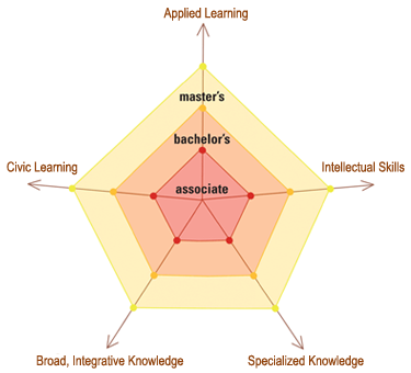
The next goal of the Geographic Science program was to develop a plan to meet these national standards outlined above while using the core indicators that drives the Degree Qualifications Profile. For the DQP, the Lumina Foundation created a series of five indicators based on AAC&U's Essential Learning Outcomes:
One of the major goals of the Geography program was to use the core indicators of the DQP to evaluate what students at the associate degree level would need to know and which skill sets they would need to apply to successfully complete and transfer from SLCC to a 4-year institution. This could be done at a course level along with from a program level by quantifying each course and the program based on each core indicator. To quantify the core indicators, the department developed a simple DQP matrix and series of data spider webs to visualize the strengths and weaknesses of the Geography program. Each spider web is a visual representation of the current state of the Geography program after going through the DQP process.
The result of the study was a restructuring of the Geography AS degree that provides students a strong academic program grounded in geography and geospatial technology, aligned with national standards and competencies, while providing a more well-rounded framework outlined by the DQP. Embedded within the degree is a stackable Geospatial Technology Certificate of Proficiency credential.
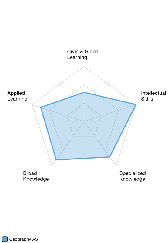
The spider web on the right is a representation of the restructured Geography program because of the DQP analysis. The department believes students going through the program will develop broad and specialized knowledge along with key technological and critical thinking skill sets that will help them be successful transferring to a 4-year institutions. The analysis also showed that, interestingly enough, civic and global learning was the weakest core indicator for the program. This may seem odd for a Geography program that specializes on global issues. The reason behind this lies in how the data was standardized for each course. Most of the geography courses discuss global issues and have assignments that addresses those issues. But the only courses that would feel the highest score were service learning courses. Before the DQP assessment, the Geography program had no service learning courses. Because of this analysis, the program is developing two service learning courses within the core of the program. One service learning course will focus on human geography, while the other service learning course will focus on physical geography. At the same time, half of the program is very technical, focusing on geospatial technology (i.e. satellite and aerial photography, geographic information systems (GIS), and global positioning systems (GPS). These courses are very specialized and focus on applied learning and less on civic or global learning. In the future, the department would like to create a service learning course for one of the geospatial technology courses.
The ultimate goal of this website is to provide not only an electronic documentation of the Geography program's DQP, but to also provide an online resource for other programs nationally who wish to implement the core indicators of the DQP within their field of study. Over the coming months and years, the website will contain program and course-level learning outcomes, ePortfolio signature assignments related to geography and spatial science, along with other resources related to curriculum and pedagogy focused around the Degree Qualification Profile.
Developed by R. Adam Dastrup, MA, GISP
Associate Professor, Geosciences Department
Salt Lake Community College, Utah
[email protected]
- Broad/Integrated Knowledge
- Specialized Knowledge
- Intellectual Skills
- Applied Learning
- Civic and Global Learning
One of the major goals of the Geography program was to use the core indicators of the DQP to evaluate what students at the associate degree level would need to know and which skill sets they would need to apply to successfully complete and transfer from SLCC to a 4-year institution. This could be done at a course level along with from a program level by quantifying each course and the program based on each core indicator. To quantify the core indicators, the department developed a simple DQP matrix and series of data spider webs to visualize the strengths and weaknesses of the Geography program. Each spider web is a visual representation of the current state of the Geography program after going through the DQP process.
The result of the study was a restructuring of the Geography AS degree that provides students a strong academic program grounded in geography and geospatial technology, aligned with national standards and competencies, while providing a more well-rounded framework outlined by the DQP. Embedded within the degree is a stackable Geospatial Technology Certificate of Proficiency credential.
The spider web on the right is a representation of the restructured Geography program because of the DQP analysis. The department believes students going through the program will develop broad and specialized knowledge along with key technological and critical thinking skill sets that will help them be successful transferring to a 4-year institutions. The analysis also showed that, interestingly enough, civic and global learning was the weakest core indicator for the program. This may seem odd for a Geography program that specializes on global issues. The reason behind this lies in how the data was standardized for each course. Most of the geography courses discuss global issues and have assignments that addresses those issues. But the only courses that would feel the highest score were service learning courses. Before the DQP assessment, the Geography program had no service learning courses. Because of this analysis, the program is developing two service learning courses within the core of the program. One service learning course will focus on human geography, while the other service learning course will focus on physical geography. At the same time, half of the program is very technical, focusing on geospatial technology (i.e. satellite and aerial photography, geographic information systems (GIS), and global positioning systems (GPS). These courses are very specialized and focus on applied learning and less on civic or global learning. In the future, the department would like to create a service learning course for one of the geospatial technology courses.
The ultimate goal of this website is to provide not only an electronic documentation of the Geography program's DQP, but to also provide an online resource for other programs nationally who wish to implement the core indicators of the DQP within their field of study. Over the coming months and years, the website will contain program and course-level learning outcomes, ePortfolio signature assignments related to geography and spatial science, along with other resources related to curriculum and pedagogy focused around the Degree Qualification Profile.
Developed by R. Adam Dastrup, MA, GISP
Associate Professor, Geosciences Department
Salt Lake Community College, Utah
[email protected]
